


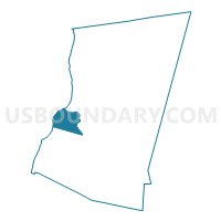
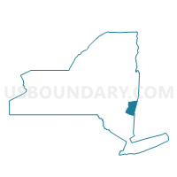
Voting District 110002, Columbia County, New York
About
Outline

Summary
| Unique Area Identifier | 626123 |
| Name | Voting District 110002 |
| County | Columbia County |
| State | New York |
| Area (square miles) | 16.34 |
| Land Area (square miles) | 14.93 |
| Water Area (square miles) | 1.40 |
| % of Land Area | 91.41 |
| % of Water Area | 8.59 |
| Latitude of the Internal Point | 42.21969420 |
| Longtitude of the Internal Point | -73.80149110 |
Maps

Graphs
Select a template below for downloading or customizing gragh for Voting District 110002, Columbia County, New York


Neighbors
Neighoring Voting District (by Name) Neighboring Voting District on the Map
- Voting District 020001, Greene County, NY
- Voting District 020003, Greene County, NY
- Voting District 040001, Greene County, NY
- Voting District 040002, Greene County, NY
- Voting District 050002, Columbia County, NY
- Voting District 050006, Columbia County, NY
- Voting District 110001, Columbia County, NY
- Voting District 130101 130201 130401, Columbia County, NY
- Voting District 130301 130302, Columbia County, NY
- Voting District 150001, Columbia County, NY
- Voting District 150002, Columbia County, NY
Top 10 Neighboring County Subdivision (by Population) Neighboring County Subdivision on the Map
- Catskill town, Greene County, NY (11,775)
- Hudson city, Columbia County, NY (6,713)
- Claverack town, Columbia County, NY (6,021)
- Greenport town, Columbia County, NY (4,165)
- Athens town, Greene County, NY (4,089)
- Livingston town, Columbia County, NY (3,646)
Top 10 Neighboring Place (by Population) Neighboring Place on the Map
Top 10 Neighboring Unified School District (by Population) Neighboring Unified School District on the Map
- Hudson City School District, NY (16,078)
- Coxsackie-Athens Central School District, NY (12,764)
- Catskill Central School District, NY (12,473)
- Taconic Hills Central School District, NY (12,275)
- Germantown Central School District, NY (4,660)
Top 10 Neighboring State Legislative District Lower Chamber (by Population) Neighboring State Legislative District Lower Chamber on the Map
Top 10 Neighboring State Legislative District Upper Chamber (by Population) Neighboring State Legislative District Upper Chamber on the Map
Top 10 Neighboring 111th Congressional District (by Population) Neighboring 111th Congressional District on the Map
Top 10 Neighboring Census Tract (by Population) Neighboring Census Tract on the Map
- Census Tract 10, Columbia County, NY (6,021)
- Census Tract 810, Greene County, NY (4,568)
- Census Tract 11, Columbia County, NY (4,165)
- Census Tract 809, Greene County, NY (4,089)
- Census Tract 14, Columbia County, NY (3,646)
- Census Tract 13, Columbia County, NY (3,238)